Enlarge image
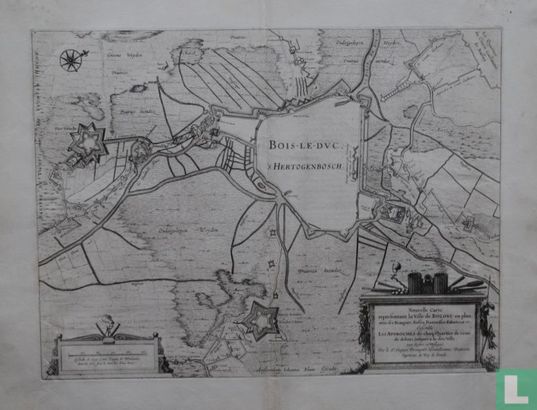
Nouvelle Carte representant la Ville de Bolduc en plan, avec ses Rempars, Fossez, Forteresses d'alentour etc.

Catalogue information
LastDodo number
5546903
Area
Prints / graphics
Title
Nouvelle Carte representant la Ville de Bolduc en plan, avec ses Rempars, Fossez, Forteresses d'alentour etc.
Artist
Technique
Year
1649
Print run
Signed
Publisher
Dimensions
38,7 x 52,2
Printing office
Theme
Details
Map of the siege of Den Bosch by the States army under Frederik Hendrik, from May 1 to September 17, 1629. Map with the fortified city in the center, fort Isabella on the left. Below right a cartouche with the French title. Copper engraving by Jacques Prempart. Published in Amsterdam in 1649 by Joan Blaeu, in: "Toonneel der stad van de Vereenighde Nederlanden, with their descriptions". Source: Rijksmuseum, 2015.
This text has been translated automatically from Dutch
Click here for the original text
Kaart van het beleg van Den Bosch door het Staatse leger onder Frederik Hendrik, van 1 mei tot 17 september 1629. Kaart met centraal de versterkte stad, links fort Isabella. Rechtsonder een cartouche met de Franse titel. Kopergravure door Jacques Prempart. Uitgegeven te Amsterdam in 1649 door Joan Blaeu, in: ,,Toonneel der steden van de Vereenighde Nederlanden, met hare beschrijvingen''.
Bron: Rijksmuseum, 2015.