Enlarge image
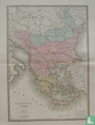
Carte Générale de la Turquie d'Europe, de la Grèce et des Iles Toniennes.

Catalogue information
LastDodo number
5026049
Area
Prints / graphics
Title
Carte Générale de la Turquie d'Europe, de la Grèce et des Iles Toniennes.
Artist
Technique
Year
1875
Print run
Signed
Publisher
Dimensions
51,3 x 35,9
Printing office
Theme
Details
Lithographed and colored map of Greece and the European part of Turkey, including a large part of Southeastern Europe (Albania, Macedonia, Montenegro, Serbia, Bulgaria). Published in Paris in 1875 by order of the Institut Geographique de Paris by Ch. Delagrave & cie, in: "Atlas Universel De Geographie Physique, Politique, Ancienne Et Moderne, Contenant Les Cartes Generales Et Privateulieres De Toutes Les Parties Du Monde (...)".
This text has been translated automatically from Dutch
Click here for the original text
Gelithografeerde en gekleurde landkaart van Griekenland en het Europese deel van Turkije, met daarbij een groot deel van Zuidoost Europa (Albanië, Macedonië, Montenegro, Servië, Bulgarije). Uitgegeven te Parijs in 1875 in opdracht van het Institut Geographique de Paris door Ch. Delagrave & cie, in: "Atlas Universel De Geographie Physique, Politique, Ancienne Et Moderne, Contenant Les Cartes Generales Et Particulieres De Toutes Les Parties Du Monde (...)".