Enlarge image
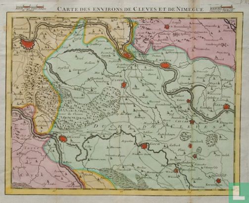
CARTE DES ENVIRONS DE CLEVES ET DE NIMEGUE

Catalogue information
LastDodo number
4936361
Area
Prints / graphics
Title
CARTE DES ENVIRONS DE CLEVES ET DE NIMEGUE
Artist
Technique
Year
1748
Print run
Signed
Publisher
Dimensions
20,5 x 26,5
Printing office
Theme
Details
Map of the area around Nijmegen, Cleve, Emmerik, Gennep, Goch and Rees. Published in Paris in 1748, in the officer's atlas "Comté d'Hollande, seigneurie d'Utrecht, comtés de Zelande, de Zutphen; et duché de Brabant & c. Dressés sur les mémoires faits par ordre des Estats Généraux et augmentés sur les observations nouvelles" , by Etienne Louis Crepy (ca.1700-1759).
This text has been translated automatically from Dutch
Click here for the original text
Landkaart van het gebied rond Nijmegen, Cleve, Emmerik, Gennep, Goch en Rees. Uitgegeven te Parijs in 1748, in het officiersatlasje "Comté d'Hollande, seigneurie d'Utrecht, comtés de Zelande, de Zutphen; et duché de Brabant &c. Dressés sur les mémoires faits par ordre des Estats Généraux et augmentés sur les observations nouvelles", door Etienne Louis Crepy (ca. 1700-1759).