Enlarge image
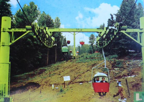
Pakistan.Hanging Chairs Ayubia , Murree Hills

Catalogue information
LastDodo number
4741701
Area
Postcards
Title
Pakistan.Hanging Chairs Ayubia , Murree Hills
City
Street
Province / region
Country
Theme
Year
Collection / set
Number on postcard
Designer
Publisher as on card
General name of the publisher
Dimensions
14.5 x 10.4 cm
Printing technique
Details
Ayubia National Park (Urdu: ایوبیہ نیشنل پارک) (shortened as Ayubia (Urdu: ایوبیہ)) is a protected area of 3,312 hectares (8,184 acres)[1] located in Abbottabad District, Khyber Pakhtunkhwa province, northern Pakistan. It was declared a national park in 1984.[2] Ayubia was named after Muhammad Ayub Khan (1958 – 1969), second President of Pakistan. The area supports temperate coniferous forest and temperate broadleaf and mixed forest ecoregion habitats, with an average elevation of 8,000 feet (2,400 m) above the sea level.[3]
Ayubia National Park is surrounded by seven major villages and four small towns of Thandiani, Nathiagali, Ayubia and Khanspur.[4] The park has been developed as a resort complex from a combination of four mini resorts of Khaira Gali, Changla Gali, Khanspur and Ghora Dhaka in Galyat.[5] Currently, it is managed by the Wildife and Parks Department of Government of Khyber Pakhtunkhwa.
Murree (Punjabi, Urdu: مری, "marī", meaning "apex"[2]) is an exurb of Islamabad and the administrative centre of Murree Tehsil, in the Punjab province in Pakistan. It is in a subdivision of Rawalpindi District and includes the parts of the Margalla Hills around Islamabad. It is located in the Pir Panjal Range, some 60 km (37 mi) northeast of Islamabad and Rawalpindi via the Murree Road.
Murree was the summer hill station of the British Raj in the Punjab Province until 1864. The city is a popular get-away destination for Islamabadis and is located on the southern slopes of the Western Himalayan foothills as they ascend northeastwards; at an average altitude of 2,291 metres (7,516 ft), it experiences pleasant summers and cold, snowy winters. The city is noted for its Tudorbethan and neo-gothic architecture dating from the colonial era.