
Enlarge image
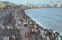
Bombay Marine Drive 70's


Catalogue information
LastDodo number
4673431
Area
Postcards
Title
Bombay Marine Drive 70's
Province / region
Country
Theme
Year
Collection / set
Number on postcard
Designer
Publisher as on card
General name of the publisher
Dimensions
14.8 x 9.5 cm
Printing technique
Details
Marine Drive is a 4.3-kilometre-long boulevard in South Mumbai in the city of Mumbai. It is a 'C'-shaped six-lane concrete road along the coast, which is a natural bay. The road links Nariman Point to Babulnath and Malabar Hill. Marine Drive is situated over reclaimed land facing west-south-west. A promenade lies parallel to this road. In 2012, the Municipal Corporation of Greater Mumbai announced that the entire road would be resurfaced, 72 years after it was originally laid.[1]
The official name for this road, though rarely used, is Netaji Subhash Chandra Bose Road. It was earlier known as Sonapur to local Marathi people. The highlight of Marine Drive is the beautiful promenade along the road where many of its residents take in a breath of fresh air and view the setting sun. The promenade is lined with palm trees. At the northern end of Marine Drive is Chowpatty Beach. This is a popular beach famed for its Bhel puri (local fast food). Many restaurants also line this stretch of the road. Further down this road lies Walkeshwar, a wealthy neighbourhood of the city, also home to the Governor of Maharashtra.
Most of the buildings which were built by wealthy Parsis sport an art deco look that was popular in the 1920s and 1930s. Miami in the United States is the only city in the world that has more art deco buildings along the seafront than Mumbai.[citation needed]
Real estate prices along the esplanade are high. A lot of celebrities live here, making it one of India's premier residential community. Many hotels dot the drive, most prominent among them being the 5-star Oberoi (formerly the Oberoi Hilton Tower however reverted to the original name as of early 2008), The Intercontinental, Hotel Marine Plaza, Sea Green Hotel and a few other smaller hotels. Marine Drive is the preferred connecting road between the central business district located at Nariman Point and the rest of the city.
South Mumbai (Marathi: दक्षिण मुंबई), the southernmost precinct of the city of Mumbai, India, comprises the city's main business localities and its adjoining areas. It is the richest urban precinct in India.
Geographically, South Mumbai lies at the southern corner of Salsette Island. Although the Constituency of South Mumbai extends from Mumbai Central to Colaba, most city residents use the term to refer to the stretch extending from Colaba to Mahim. This delimitation is also known as Mumbai City or Island City. The area is delimited on the east by Mumbai harbour and on the west by the Arabian Sea. The areas from Bandra and beyond form a part of Suburban Mumbai. See also Mumbai City District.
Mumbai /mʊmˈbaɪ/ (also known as Bombay) is the capital city of the Indian state of Maharashtra. It is the most populous city in India, second most populous metropolitan area in India, and the fifth most populous city in the world, with an estimated city population of 18.4 million and metropolitan area population of 20.7 million as of 2011.[6] Along with the urban areas, including the cities of Navi Mumbai, Thane, Bhiwandi, Kalyan, it is one of the most populous urban regions in the world.[7] Mumbai lies on the west coast of India and has a deep natural harbour. In 2009, Mumbai was named an alpha world city.[8] It is also the wealthiest city in India,[9] and has the highest GDP of any city in South, West or Central Asia.
The seven islands that came to constitute Mumbai were home to communities of fishing colonies.[10] For centuries, the islands were under the control of successive indigenous empires before being ceded to the Portuguese and subsequently to the British East India Company. During the mid-18th century, Bombay was reshaped by the Hornby Vellard project,[11] [11] which undertook reclamation of the area between the seven islands from the sea.[12] Along with construction of major roads and railways, the reclamation project, completed in 1845, transformed Bombay into a major seaport on the Arabian Sea. Bombay in the 19th century was characterized by economic and educational development. During the early 20th century it became a strong base for the Indian independence movement. Upon India's independence in 1947 the city was incorporated into Bombay State. In 1960, following the Samyukta Maharashtra movement, a new state of Maharashtra was created with Bombay as the capital. The city was renamed Mumbai in 1996