Enlarge image
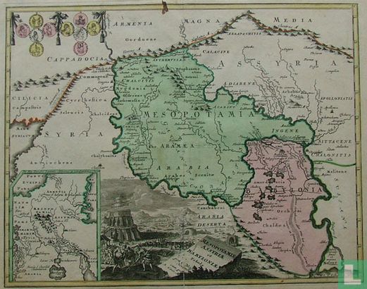
Mesopotamie Assyriae et Babylonie tabul

Catalogue information
LastDodo number
3833439
Area
Maps and globes
Title
Mesopotamie Assyriae et Babylonie tabul
Type
Manufacturer / publisher
Country of publication
Cartographer / designer
Year
1720
Print Run
Collection / set
Number in collection
Addition to number
Scale
Continent
Country
Not independent areas
Former countries and colonies
Region / province
City
Material
Type of colouring
Language / dialect
Theme
Dimensions
40 X 31 cm (beeld), 42 bij 34 cm (papier)
ISBN13
ISBN10
Details
Attractive map of Mesopotamia, with an inset of Armenia and Syria, engraved ducats and a beautiful cartouche with the tower of Babylon, surrounded by people and simple houses.
This text has been translated automatically from Dutch
Click here for the original text
Aantrekkelijk uitgevoerde kaart van Mesopotamië, met een inzet van Armenië en Syrië, gegraveerde dukaten en een mooie cartouche met de toren van Babylon, met daaromheen volk en eenvoudige woningen.