

Enlarge image
Early maps and charts of the west coast of North America


Catalogue information
LastDodo number
3288785
Area
Maps and globes
Title
Early maps and charts of the west coast of North America
Type
Manufacturer / publisher
Country of publication
Cartographer / designer
Year
1985
Print Run
Collection / set
Number in collection
351
Addition to number
Scale
Continent
Country
Not independent areas
Former countries and colonies
Region / province
City
Material
Type of colouring
Language / dialect
Theme
Dimensions
59 x 78
ISBN13
ISBN10
Details
# 351 of 500.
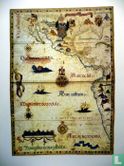
Early maps and charts of the west coast of North America on the history of maps and sea charts, cartographers and publishers and some periods of American history.
The 32 page accompanying booklet provides an introduction & full details on each map.
Publishied in a limited edition of 500.
The maps and charts in the protfolio are reproductions of the originals in the collections of the museums and libraries. They were printed on "Hollands luxe koperdruk" on the presses of BV Kunstdrukkerij Mercurius-Wormerveer, The Netherlands.


