Enlarge image
Amsterdam plattegrond

Catalogue information
LastDodo number
6261129
Area
Maps and globes
Title
Amsterdam plattegrond
Type
Manufacturer / publisher
Country of publication
Cartographer / designer
Year
1862
Print Run
1
Collection / set
Number in collection
Addition to number
Scale
Continent
Country
Not independent areas
Former countries and colonies
Region / province
Material
Type of colouring
Language / dialect
Theme
Dimensions
400 x 300
ISBN13
ISBN10
Details
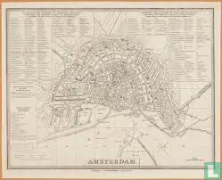
Description Amsterdam Ninth edition of the map of Amsterdam on a scale of approx. 1: 12,000, published by G.W. Tielkemeijer. Orientation: southwest up. Document type card Manufacturer Tielkemeijer, G.W. Dating from 1860 approx. To 1864 approx. Source: Amsterdam municipal archives
This text has been translated automatically from Dutch
Click here for the original text
Beschrijving Amsterdam
Negende editie van de kaart van Amsterdam op schaal ca. 1:12.000, uitgegeven door G.W. Tielkemeijer. Oriëntatie: zuidwest boven.
Documenttypekaart
VervaardigerTielkemeijer, G.W.
Datering 1860 ca. t/m 1864 ca.
Bron: gemeentearchief Amsterdam
