Enlarge image
Obsidio St. Geertruydenbergae

Catalogue information
LastDodo number
5546795
Area
Prints / graphics
Title
Obsidio St. Geertruydenbergae
Artist
Technique
Year
1649
Print run
Signed
Publisher
Dimensions
44,3 x 56,9
Printing office
Theme
Details
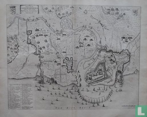
Map of the siege and conquest of Geertruidenberg by the States army under Prince Maurits from 28 March to 26 June 1593. Below right the city, the closed harbor and the camp of Prince Maurits. Left the equestrian quarter and the army camp of Mansfeld near Waspik. Bottom left the legend 1-31 in Dutch. Copper engraving appeared in the famous City Book "Toonneel der stad van de vereenighde Nederlanden, with their descriptions", published by Joan Blaeu in Amsterdam in 1649.
This text has been translated automatically from Dutch
Click here for the original text
Kaart van de belegering en verovering van Geertruidenberg door het Staatse leger onder prins Maurits van 28 maart tot 26 juni 1593. Rechtsonder de stad, de afgesloten haven en het kamp van prins Maurits. Links het ruiterkwartier en het legerkamp van Mansfeld bij Waspik. Linksonder de legenda 1-31 in het Nederlands. Kopergravure verschenen in het beroemde Stedenboek "Toonneel der steden van de vereenighde Nederlanden, met hare beschrijvingen", uitgegeven door Joan Blaeu te Amsterdam in 1649.