Enlarge image
Kaart van de Provincie Zeeland Verveeld in Arrondissementen en regeterlijke Kantons

Catalogue information
LastDodo number
5413923
Area
Prints / graphics
Title
Kaart van de Provincie Zeeland Verveeld in Arrondissementen en regeterlijke Kantons
Artist
Technique
Year
Print run
Signed
Publisher
Dimensions
45,3 x 56,1
Printing office
Theme
Details
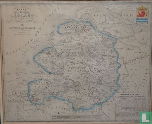
Map of the province of Zeeland, with the title at the top left. Top right the colored coat of arms of the province of Zeeland. Legend and scale sticks at the bottom. Lithograph, made by F. Desterbeck. Signed in the lower right corner of the print. Border colored. Published in "New Atlas of the Kingdom of the Netherlands", Amsterdam, Wed. G.H. van Keulen, c. 1868. The map is undated in print. Dating is based on the fact that the Zeeland Railway has progressed to Goes. Such was the case in 1868.
This text has been translated automatically from Dutch
Click here for the original text
Landkaart van de provincie Zeeland, met de titel linksboven. Rechtsboven het gekleurde wapen van de provincie Zeeland. Onderaan legenda en schaalstokken. Litho, vervaardigd door F. Desterbeck. Gesigneerd rechtsonder in druk. Grensgekleurd. Verschenen in "Nieuwe Atlas van het Koningrijk der Nederlanden", Amsterdam, Wed. G.H. van Keulen, ca. 1868. De kaart is niet gedateerd in druk. Datering berust op het feit dat de Zeeuwse Spoorlijn tot Goes gevorderd is. Dat was het geval in 1868.