Enlarge image
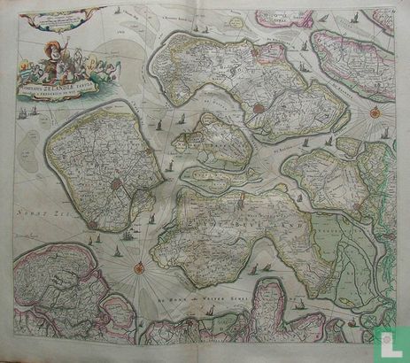
Comitatus Zelandiae Tabula

Catalogue information
LastDodo number
3823051
Area
Maps and globes
Title
Comitatus Zelandiae Tabula
Type
Manufacturer / publisher
Country of publication
Cartographer / designer
Year
1670
Print Run
Collection / set
Number in collection
Addition to number
Scale
Continent
Country
Not independent areas
Former countries and colonies
Region / province
City
Material
Type of colouring
Language / dialect
Theme
Dimensions
54 X 46 centimeter (beeldformaat), goede marges
ISBN13
ISBN10
Details
Very nice map of Zeeland with beautiful decorations of cartouches and ships on the Western Scheldt. The Zeeland islands of Schouwen, Duiveland, Noord Beveland, Wolfersdijk are beautiful.
This text has been translated automatically from Dutch
Click here for the original text
Zeer mooie kaart van Zeeland met mooie decoraties van cartouches en schepen op de Westerschelde.
De zeeuwse eilanden Schouwen, Duiveland, Noord Beveland, Wolfersdijk staan er mooi op.